
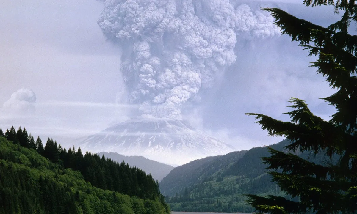
Forty-three years ago today, Mt. St. Helens erupted in southwestern Washington. And to this day, it remains the most destructive volcanic eruption in U.S. history. The eruption killed 57 people, destroyed hundreds of homes and dozens of bridges, and debris ruined 15 miles of railroad tracks and 185 miles of highway. Over a nine-hour eruption, the mountain spewed so much hot ash, it burned 230 square miles of forest and buried a 14-mile stretch of the North Fork Toutle Valley in a pile of volcanic debris an average of 150 feet deep.
Videos by Outdoors
Since then, environmentalists have worked to rehabilitate the landscape, and it has been recovering. In a short NASA documentary showing aerial footage of the eruption zone over the last several decades, you can see that the area has grown far greener over recent years—a good sign that the land is renewing itself after the eruption scarred it. But some aspects of the land—including the mountain’s silhouette—will be forever changed.
The history of the eruption
The historic eruption of Mt. St. Helens wasn’t just a one-day affair. On March 16, 1980, the area started experiencing a series of small earthquakes. Days later, on March 27, the mountain erupted for the first time in over 100 years. A blast of steam cut through the mountain’s snowy cap, and created a 250-foot crater. That crater grew to about 1,300 feet within a week, and then the mountain started bulging.
Before the major eruption on May 18, 1980, up to 10,000 earthquakes had been recorded in the preceding weeks, and so many small eruptions that at times the mountain averaged up one per hour, according to a history of the eruption from the USGS. As magma rose high into the volcano, the mountain’s bulge expanded horizontally to about 450 feet, growing at a pace of up to 6.5 feet per day.
The main eruption happened at 8:32 a.m. on May 18, in conjunction with a magnitude 5.1 earthquake that rocked the valley. That bulge growing out of the side of the mountain fell away into a landslide so massive, it remains the “largest debris avalanche on Earth in recorded history,” according to USGS. It clocks the total volume of the debris at 2.5 cubic kilometers, which would be enough to fill one million Olympic swimming pools. There was so much of it that “[a]sh was deposited in at least 11 states and made a complete circuit of the globe by May 29,” according to The Oregonian.
The eruption changed tourist hotspots like Spirit Lake
Before the 1980 eruption, Mt. St. Helens was a gorgeous backdrop for popular vacation destinations. Quite a few summer camps and lodges situated themselves around the shores of Spirit Lake, including Spirit Lake Lodge and Mt. St. Helens Lodge. Both were buried by volcanic debris. The owner of Mt. St. Helens Lodge, Harry Truman, died from the eruption.
More than 40 years later, you can still see logs floating on the surface of the lake, from trees leveled by the 1980 eruption. This “log mat” once covered about 70 percent of the lake’s surface, and today covers about 20 percent, as most of the tree trunks have sunken. But it’s actually now an important part of the lake’s ecosystem, according to an article from NASA’s Earth Observatory blog: “Winds grind the logs together with such force that the logs ‘shed’ carbon and nitrogen into the lake,” NASA reports. “The wood itself adds organic carbon to the lake sediments. Meanwhile, algae and bacteria growing on the logs can take nitrogen from the atmosphere and convert it into forms more usable by other aquatic life,” contributing to food sources in the lake for species including rainbow trout.
Incredible photos of the volcano in action
As the volcano erupted and sent plumes of ash as high as 650 in the air, of course it piqued the curiosity of some intrepid photographers. In 2014, the Oregonian published never-before-seen images of the eruption captured by a retired geologist, Richard Bowen, who saw the eruption from his home in Portland and called a pilot friend to ask him to take him closer to it. Bowen flew remarkably close to the volcano, with his 11-year-old daughter in tow, to capture eye-level images of the smoke and ash plumes that rose out of the mountain. As they flew, they saw red, pink, and purple lightning. Bowen kept the photographs stored away for over 30 years. They were published a few years after his death in 2010.
The mountain’s forests recover—but are forever changed
When the volcano erupted in 1980, it forever changed Mt. St. Helens. The force of the explosion was so strong that the mountain peak collapsed, reducing its elevation from 9,677 feet to 8,363 feet. Where there was once a dramatic summit, there is now a massive crater. Mudslides brought down forests, ash buried woodlands in up to 600 feet of debris, and the eruption sent nearby Spirit Lake shooting hundreds of feet in the air, dragging logs down from the foothills when the water came crashing back down to Earth.
Two decades after the eruption, it still looked “like a moonscape,” according to Sean Healey, a research ecologist for the U.S. Forest Service, who was interviewed for the NASA video commemorating the 40th anniversary of the eruption. There were “pieces of pumice on the ground, no vegetation. It has been a place of extraordinary change over the last 40 years, from a really beautiful, old-growth forest to a moonscape, and back again.”
Watching the way the environment has regenerated itself has been an “unprecedented” opportunity for scientists to watch how land recovers from the catastrophe, according to a NASA report about the forest’s recovery.
On the mountain today
Debris from the eruption is still relevant today, even after all these years. Yesterday, May 17, a “debris flow” around Mt. St. Helens blocked a roadway and destroyed a bridge—and left people stranded on the mountain. Weeks of warm weather likely led to the issue, according to a report from The Weather Channel, which said the mud and debris is likely left over from that explosion in 1980. It caused such havoc on roadways that 12 people and a dog had to be airlifted to safety.


Great to see how the environment has regenerated itself after the destructive Mt. St. Helens eruption.