
Area 51 is one of the best-known secrets of the U.S. government. While it’s commonly believed that the military primarily uses the base to research and test experimental aircraft, weapons, and maybe even alien technology, nobody knows. But if you want to believe and don’t want to get arrested while doing the Naratu run, the best way to find out is hiking Tikaboo Peak.
Videos by Outdoors
Located about 100 miles north of Las Vegas and in the Pahranagat Range, Tikaboo Peak is the closest publicly accessible vantage point to view the mysterious military base. While the trail is a little more than a mile, it’s in no way an easy adventure. That’s why in this article, we’ll talk about what it is, where it’s at, how to get there, and most importantly if it’s worth it.
Tikaboo Peak
Nearly 30 years ago, those curious about Area 51 had two options if they wanted a glimpse of what was happening on base and the salt flat Groom Lake. They were called “White Sides” and “Freedom Ridge” and they sat within approximately 12 miles of the base. But the government closed off those areas in 1995 to prevent people from taking pictures of base activity. That left the distant third option of Tikaboo Peak as the only place to grab an elevated view of the base.
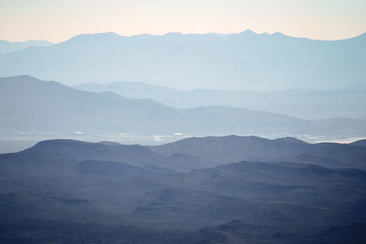
By the numbers, Tikaboo Peak stands approximately 7,900 feet tall and if you look to the west, it offers a straight-line view of Area 51. While the base is 26 miles away, some say you can see it from Tikaboo Peak on a clear day, but you generally need to look through a powerful telescoping lens to get a clear view. And even then, all you really see are a few buildings and an air strip.
According to internet lore, the first official ascent of Tikaboo Peak — “official” in that they wrote about it — happened on March 12, 1994 by a group of conspiracy theorists. They reported finding a hasty shelter and some trash, but also “one of the better mountain top views I had ever seen.”
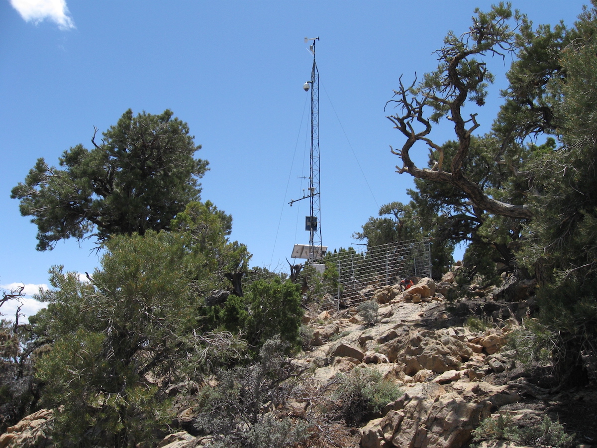
While the peak’s unofficial purpose is to keep the government in check, today, the official purpose is that it’s part of the National Geological Survey. At the top, you’ll find a USGS marker along with a weather monitoring system, which you can’t miss because it’s a tall tower fitted with a camera and solar panels.
Getting to Tikaboo
Tikaboo Peak is about 20 miles west of the nearest populated area, a tiny town called Alamo, in a remote part of Lincoln County, Nevada. With that said, getting to the trailhead might be the most treacherous part of the journey. It requires a combination of interstate and highway driving until you turn off on an unmarked dirt road, dubbed the Badger Valley Road. As you follow the road, you travel west, south, and northwest for 22 miles.
While the road is graded, it’s very sandy and not immune to falling rocks, debris, and erosion. And while there are videos of people driving the full length in a two-wheel drive vehicle, most people recommend driving something with four-wheel drive and high clearance.
It’s such a tough road, in fact, on a recent trek, digital creator SB Vegas Adventure encountered a massive split in the road and experienced a flat tire. Although he was in the recommended 4×4, he chose not to risk driving on a patched tire (or a spare) and opted to walk a few extra miles instead.
The reason is most people consider the biggest hazard to hiking Tikaboo Peak is your car breaking down and not just because of the road. Because the area gets snowy in the winter time, most people recommend hiking Tikaboo Peak between May and November.
Hiking the Trail
It’s common for hikers to do the hike over a two- or three-day trip. One day for driving and another day for hiking. There’s a camping area — it’s legal to camp on Bureau of Land Management land and pretty much anywhere in Nevada without a permit – at the base of the trailhead. Also, for the best views, it’s generally recommended that you start your hike in the morning, so the sun will be at your back when you look out toward Area 51.
While there are a variety of trail maps and even GPS guides, there’s no official trail. People who hike it often follow hasty markings and cairns. The vast majority of the trail is covered in loose rock and small cacti, so there’s lots of scrambling and vegetation on steep inclines. Plus, the range is at a higher elevation, close to 7,000 feet, than the surrounding desert, which brings cooler temperatures.
According to Gaia GPS, Tikaboo Peak trail is 1.4 miles long, making it a 2.8-mile round trip, with 1,053 feet of elevation gain. And if you’re able to stay on the trail, it takes approximately 34 minutes to complete. However, if you get lost on the way there or the way back, which is common, it could take much longer.
Directions
According to the National Oceanic and Atmospheric Administration, the best way to approach the peak is by helicopter and a distant second is by ground. NOAA recommends that you:
- Start from the Pahranagat Wildlife Refuge Headquarters and drive about three miles south on the access road.
- Travel southwest along the same road for about eight miles to a T-junction with a track road to the north and northwest.
- Take the road up the valley between Pahranagat Range for about 18 miles to the base of the highest point and the end of the road.
From the end of the road, NOAA said it’s “Probably a one to two hour pack (northwest) of the head of the draw at the end of the (west) fork of the valley to the top and station site.”
For True Believers
The journey to Tikaboo Peak is a difficult one, to say the least. It requires driving long miles on something that loosely fits the definition of a modern road and then a mildly challenging hike all for a view that’s not much better than what you’ll see on Google Earth. Additionally, in researching this article, we reached out to representatives in Lincoln County and local hiking groups. All of them said they didn’t know much about Tikaboo Peak or they haven’t been in the area for decades. With that said, if seeing Area 51 with your own eyes is important to you or experiencing the thrill of perhaps witnessing something they don’t want you to see, then hiking Tikaboo Peak is 100 percent worth it.


Pingback: Top 10 Outlandish Things You Can Do in Nevada - Listverse - Nevada Local News
Pingback: Top 10 Outlandish Things You Can Do in Nevada - Newspapper
Pingback: Top 10 Outlandish Things You Can Do in Nevada - Welcome
Pingback: Top 10 Outlandish Things You Can Do in Nevada
Pingback: Top 10 Outlandish Things You Can Do in Nevada - PoopChute.com