
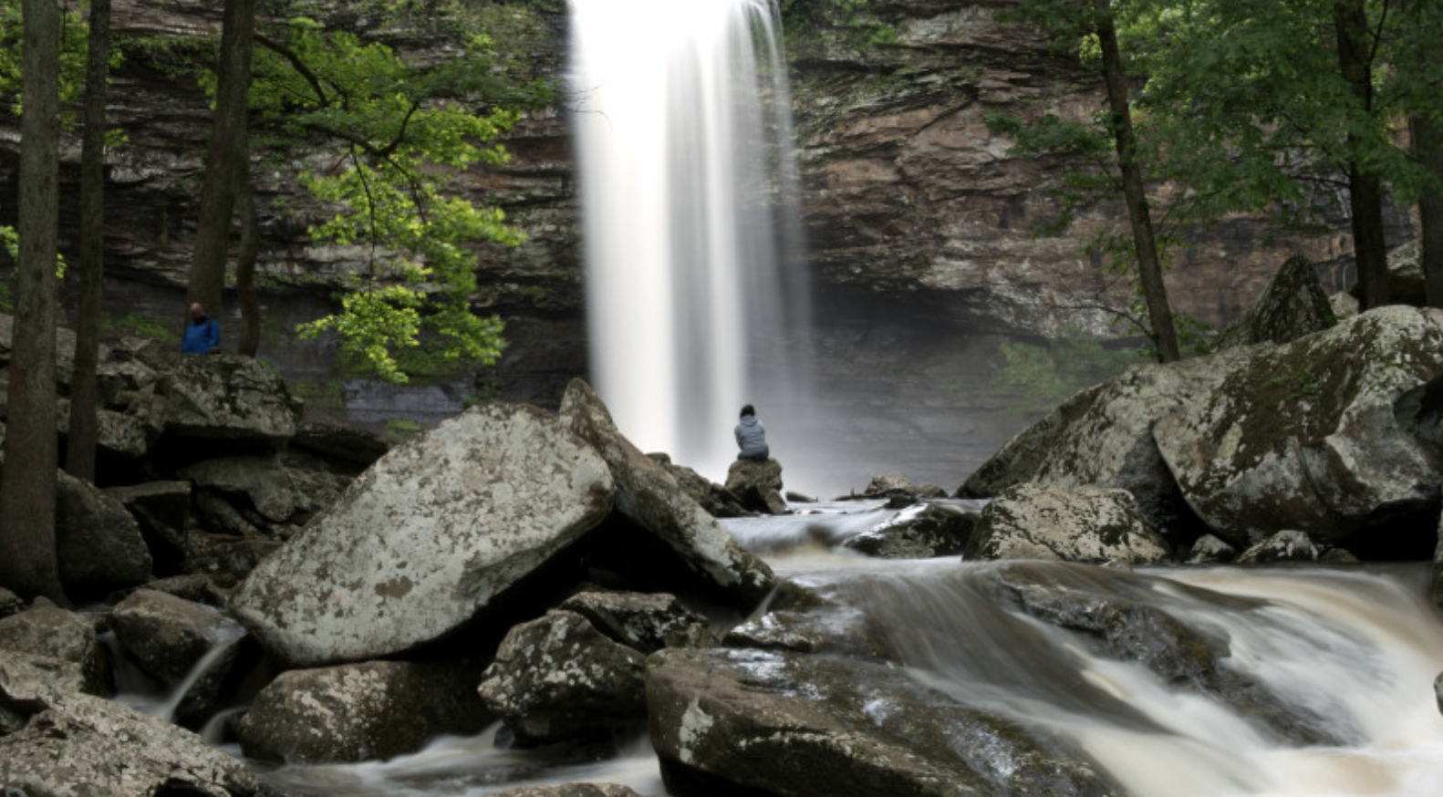
Many hiking enthusiasts come to Arkansas for the Ozarks, but there’s plenty of outdoor magic to be found throughout the Natural State, from towering waterfalls and soaring mountains to babbling creeks and verdant forests. The best part? Some of the most unforgettable adventures you’ll have are located just a short drive away from Little Rock. Here are the top trails that should be on your must-hike list.
Videos by Outdoors
Winding Stairs Trail

Where: Montgomery County, Arkansas
Length: 4.5 miles out-and-back
Time: 2 hours
Difficulty: Moderate
What to Expect: Located in Ouachita National Forest, this scenic trail has it all: lush forests, caves, cascading waterfalls, and a deep blue pool perfect for lazy floating. Be sure to bring waterproof shoes, as hikers have to pass right through Baylock Creek.
Pets Permitted: Dogs are welcome, but must be on a leash.
Arkansas River Trail

Where: Pulaski County, Arkansas
Length: 88 miles loop
Time: Varies
Difficulty: Easy
What to Expect: Passing through Little Rock, North Little Rock, Maumelle, and Conway, this expansive recreational trail is popular with hikers and cyclists alike. The route spans across wooded wetlands, open fields, and historic bridges, and offers access to some of the state’s top parks, including Burns Park.
Pets Permitted: Dogs are welcome, but must be on a leash.
Collins Creek Trail
Best for Families
Where: Cleburne County, Arkansas

Length: 1.2 miles out-and-back
Time: 30 minutes
Difficulty: Easy
What to Expect: A haven for trout, this creek doesn’t have just one waterfall, but a series of cascades that flow year-round. The kid-friendly hike up the ravine and back is especially beloved by families.
Pets Permitted: Dogs are welcome, but must be on a leash.
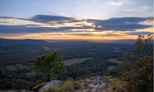
Signal Hill Trail
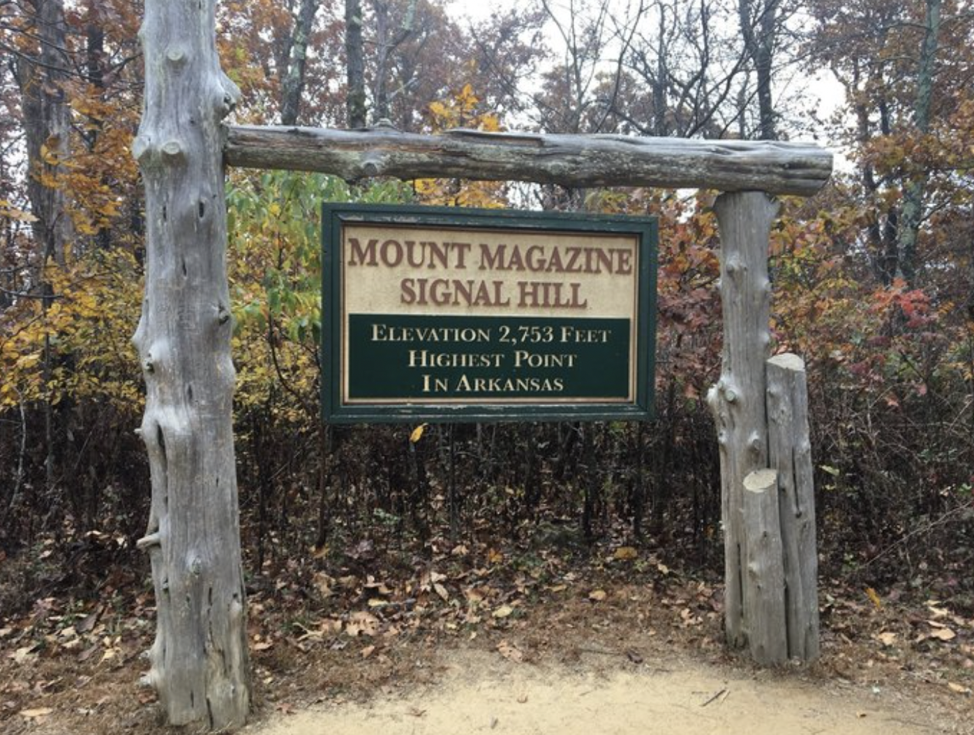
Where: Logan County, Arkansas
Length: 1.8 miles loop
Time: 1 hour
Difficulty: Moderate
What to Expect: At an elevation of 2,753 feet above sea level, Signal Hill on Mount Magazine is the highest point in all of Arkansas. But don’t be intimidated—there’s less than a 200 feet climb between the trail’s high and low points, so this particular hike mostly feels like a relaxing walk in the woods that’s particularly beautiful in the spring when flowers are blooming.
Pets Permitted: Dogs are welcome, but must be on a leash.
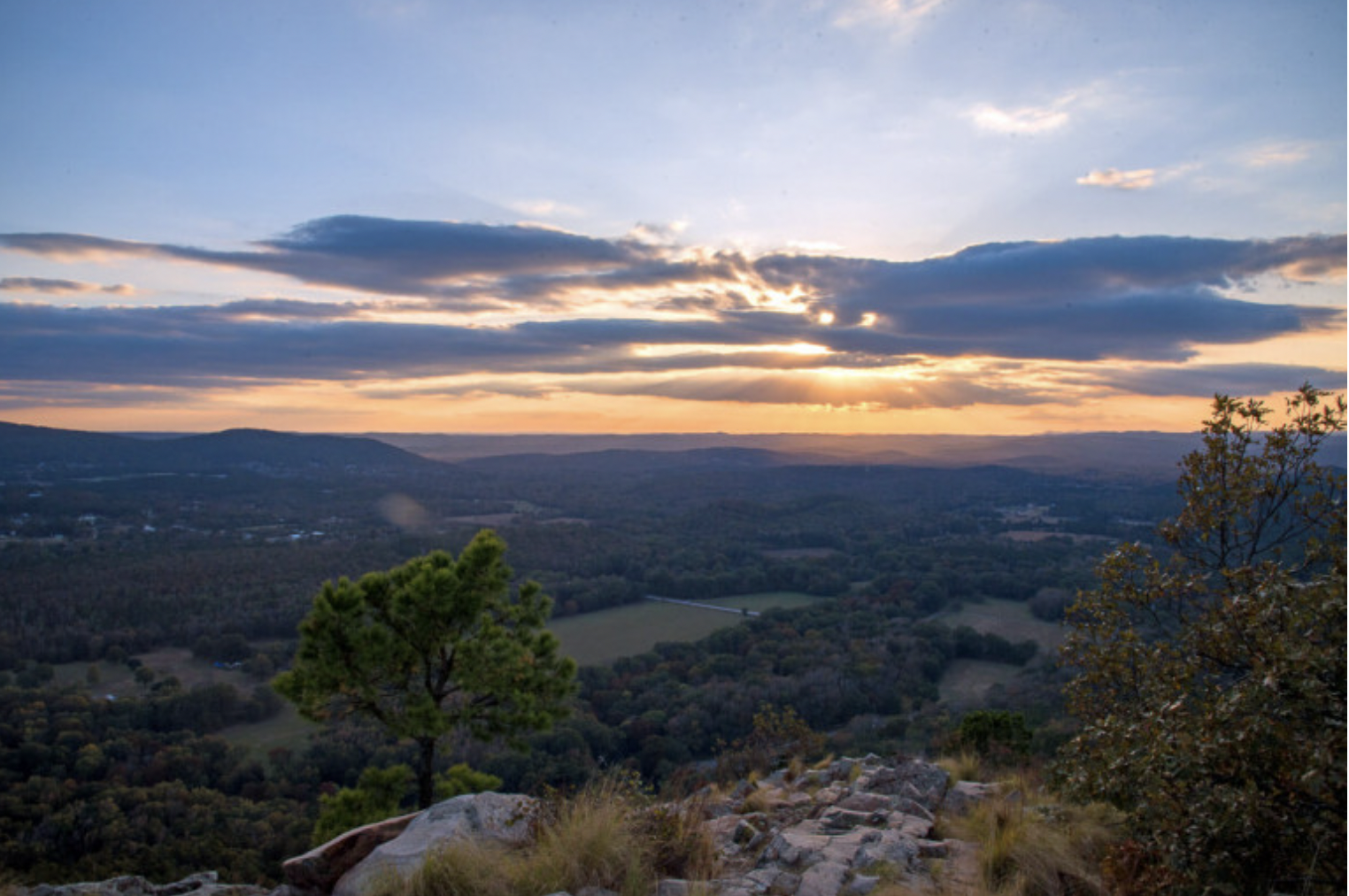
North Rim Trail
Best For Views

Where: Logan County, Arkansas
Length: 4.2 miles loop
Time: 2 hours
Difficulty: Moderate
What to Expect: For the best views from Mount Magazine, you actually want to head to the North Rim Trail which runs along the north rim of the mountain. You’ll be rewarded with panoramic scenes of the Arkansas River Valley and off into the Ozarks.
Pets Permitted: Dogs are welcome, but must be on a leash.
Sugarloaf Mountain Summit Trail

Where: Cleburne County, Arkansas
Length: 0.8 miles out-and-back
Time: 30 minutes
Difficulty: Moderate
What to Expect: A towering stone bluff formation that stands about 1,000 feet tall in the middle of Greers Ferry Lake, Sugarloaf Mountain is the only island hiking option in Arkansas. The steep trail takes you to the summit—and some truly jaw-dropping views. To get there, board a Sugar Loaf Shuttle from Fairfield Bay Marina.
Pets Permitted: Dogs are welcome, but must be on a leash.
Eagle Rock Loop

Where: Pike County, Arkansas
Length: 26.5 miles loop
Time: Multiple days
Difficulty: Hard
What to Expect: The longest backpacking loop in Arkansas, Eagle Rock is perfect for hikers looking for a challenge. The hike, which follows a 100-year old postal route and wagon trail through Ouachita National Forest, typically takes three days. Look out for creek crossings, rocky ridges, and idyllic swimming holes.
Pets Permitted: Dogs are welcome, but must be on a leash.
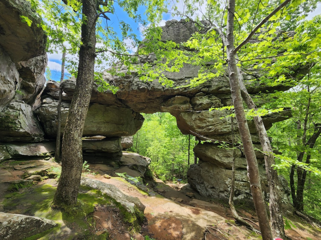
Pedestal Rocks and Kings Bluff Scenic Loop

Where: Pope County, Arkansas
Length: 4.6 miles loop
Time: 2 hours
Difficulty: Moderate
What to Expect: Tucked in the Ozark National Forest, this Instagram-worthy trail leads hikers through epic rock formations like caves, arches, and natural bridges, up to steep cliffs with never-ending views of the valley below. One highlight is the towering pedestal rocks that reach up to the tops of the forest canopy.
Pets Permitted: Dogs are welcome, but must be on a leash.
Peak Trail

Where: Garland County, Arkansas
Length: 1.3 miles out-and-back
Time: 1 hour
Difficulty: Easy
What to Expect: Follow this easy forest trek up to the Art Deco Mountain Hot Springs Mountain Tower, where you can enjoy panoramic views of the Ouachita Mountains, Hot Springs Mountain, and Diamond Lakes area from the observation deck.
Pets Permitted: Dogs are welcome, but must be on a leash.
Mount Nebo Rim Trail
Best for Views

Where: Yell County, Arkansas
Length: 3.6 miles loop
Time: 3 hours
Difficulty: Moderate
What to Expect: Boasting what might just be the most sweeping mountain views in the state, Mount Nebo has unobstructed sunrise and sunset viewing points. On your way up, you’ll pass a pond, waterfall, and boulders. Mount Nebo is a certified Trail of Tears National Historic Trail Site for the Cherokee, Chickasaw, Choctaw, Muscogee and Seminole people that traveled along the Arkansas River below Mount Nebo in the 1830s.
Pets Permitted: Dogs are welcome, but must be on a leash.
Pinnacle Mountain West Summit Trail
Where: Pulaski County, Arkansas
Length: 1.5 miles out-and-back
Time: 1.5 hours
Difficulty: Hard
What to Expect: Just a short drive from Little Rock itself, the rocky Pinnacle Mountain West Summit Trail is one of the state’s most popular hikes. Gear up for a bit of a scramble and steep climb to the peak with spectacular views of Lake Maumelle, the Ouachita Mountains, the Arkansas River, and west Little Rock.
Pets Permitted: Dogs are welcome, but must be on a leash.
Seven Hollows Trail
Where: Conway County, Arkansas
Length: 5 miles loop
Time: 2 hours
Difficulty: Moderate
What to Expect: Petit Jean State Park—the area that led to the creation of the state park system itself—is a haven for hikers, and Seven Hollows Trail is one of its most popular. It’s full of unique sites, including a natural bridge, stone arches, and Turtle Rocks (a rock formation that looks like the shells of turtles). Don’t skip the short spur trail that leads to a small but dazzling grotto waterfall—the perfect spot for a picnic.
Pets Permitted: Dogs are welcome, but must be on a leash.
Cedar Falls Trail
Where: Conway County, Arkansas
Length: 1.9 miles out-and-back
Time: 1 hour
Difficulty: Moderate
What to Expect: Another famous trail in Petit Jean State Park, Cedar Falls Trail leads to one of the most photographed natural wonders in Arkansas: a 95-feet continuously flowing waterfall. Along the way, you’ll enjoy a true adventure, winding down into the deep Cedar Creek Canyon, past massive boulders and overhangs.
Pets Permitted: Dogs are welcome, but must be on a leash.
Rock House Cave Trail

Where: Conway County, Arkansas
Length: .25 miles out-and-back
Time: 30 minutes
Difficulty: Easy
What to Expect: Sometimes the best part of a hike is its destination, and this trail has a very special one. Probably used by Native Americans starting around 8,000 years ago, Rock House Cave contains approximately 105 rock art images or pictographs on its ceiling and walls.
Pets Permitted: Dogs are welcome, but must be on a leash.
Rattlesnake Ridge Cliffbrake Trail

Where: Pulaski County, Arkansas
Length: 3.2 miles out-and-back
Time: 2 hours
Difficulty: Moderate
What to Expect: Located in a conservation area for rare and protected species including the southeastern bat, the western diamondback rattlesnake, the eastern collared lizard, and Wright’s cliffbrake, a western desert fern, this rugged trail takes hikers through the Ouachita Mountain Sandstone Outcrop Barrens, one of hottest and driest places in the state.
Pets Permitted: Dogs are welcome, but must be on a leash.


I am familiar enough with Hot Springs National Park. You might add whether dogs on a leash may enter the Hot Springs Mountain Tower. Unless I am mistaken or the dog is a service animal, I don’t believe that is permitted. I guess that would apply to the Peak Trail.
Some people wanting to see the view but not part of a group might be unhappy with the way things are worded once arriving at the tower unless I am mistaken.