Modern-day hiking includes the help of phones, GPS devices, and/or Apple Watches—but what happens when all of that fancy tech glitches or service gets patchy? A man in the wilderness near Vancouver found out what happens when tech fails you while hiking.
Videos by Outdoors
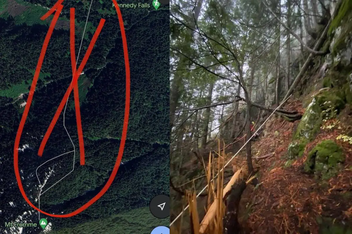
This past Saturday, the North Shore Search and Rescue (SAR) in British Columbia, Canada received a call to rescue a hiker near one of the North Shore Mountains and Mount Fromme. The hiker was apparently following a Google Maps trail that did not actually exist.
The team arrived by helicopter to help the man, who was stranded on a cliff face, just in time, as a thick fog was rolling in—if it had been much later, flying would have been impossible. The hiker did not have any light source and was difficult to spot in the thick tree cover.
It was already getting dark when the SAR crew dropped below the hiker to be able to get him in a harness and find a place where the helicopter could safely rescue him. At this point, the clouds were thickening even more, threatening visibility. Thankfully, the SAR team extracted the hiker before they lost visibility.
This is not the first time a rescue in that area has been needed. Despite the suggestion of a trail on Google Maps, in reality, there is no connecting path between Mount Fromme and Kennedy Falls. The rescue team said this is the third time they have received a call about a hiker needing help near Mount Fromme, possibly due to this fake Google Maps trail. In 2021, a person went missing and was later found deceased in the area. Thankfully, since the event, Google Maps has removed the incorrect path from its app.
Have a Backup Navigation Plan
North Shore SAR advises that hikers should never depend exclusively on Google Maps for trail navigation and says there are better apps specifically designed for hikers that are more trustworthy. The organization also encourages hikers to bring the right equipment when heading out for a hike, including equipment that you’d need in an emergency.
Thankfully, in this instance, the hiker survived, but it begs the question: What other Google Maps or GPS trails are wrong? According to Bear Grylls, there is no replacement for having a map and compass navigation skills, especially in the wild—even if you have a Garmin GPS in your bag. A paper map and compass is the best option and a smartphone a close second, but only if you also have an external battery pack. Learning how to navigate is essential when service drops out and weather turns bad. Trust in your knowledge is the safest way to venture out on a hike.