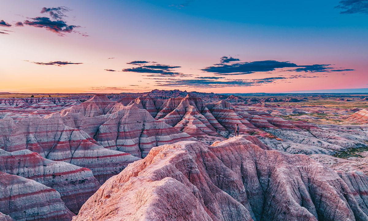
Badlands National Park is not the only place in the United States to see the unique formations the Lakota people called “mako sica” or “bad lands.” This geological oddity is characterized by soft, sedimentary rocks that have been extensively eroded by wind and water. They form in arid environments with clay-rich soils over millions of years.
Videos by Outdoors
Badlands are amazing because they can look dramatically different from site to site. Their appearance depends on the natural geology and elements of the area they are found in. This can range in both formations (such as hoodoos, ravines, and spires) and color (ranging from dramatic striations of deep blues to bright reds). Some appear as hills with deep gullies cut through their faces, while others feature stand-alone spires. Others, still, may appear as bulbous rocks, garnering them names like mushroom, toadstool, or cracked eggs. Because of this, no two badlands look the same.
Badlands National Park is certainly a wonderful place to visit, however, it would be a disservice to end your tour there. Badlands can be found all over the central and western United States, and each is worthy of a visit. From Oregon to Kansas, here is a guide to four often-overlooked badlands.
Kansas
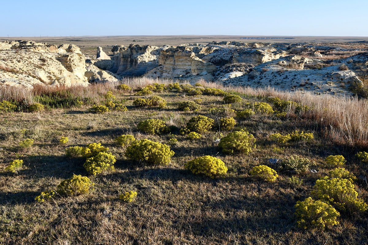
Out of all states that feature badlands, perhaps the most surprising is Kansas. Western Kansas has the Niobrara chalk badlands that formed from an ancient sea that covered the area more than 80 million years ago. These badlands are widely regarded in paleontological circles because fossils of mosasaurs—aquatic reptiles that reach over 50 feet in length—are commonly found here. Fossils of other aquatic species, including giant clams and birds, have also been uncovered in the area.
Erupting from the prairie, the Niobrara chalk formations are seen nowhere better than the Little Jerusalem Badlands State Park. Located in northwest Kansas, near the town of Oakley, this 332-acre park is the only badland area in the state on public land––though privately owned Monument Rock and Castle Rock areas do allow visitors.
Little Jeruseulm features dramatic pinnacles, hoodoos, and canyonlands, which is thought to have given it its name; from a distance, it is said to resemble the walled city of Jerusalem. There are two trails that allow visitors to explore the park, but the best one is the 2.4-mile Life on the Rocks Trail, which leads users around the southern edge of the formations in the park, granting beautiful views and a chance to experience some of Kansas’s native plants and animals. Those interested in exploring the area in more depth, including hiking to the bottom of the formations, can sign up for a guided hike (which usually happens once a week).
Entry to the park is $5 per vehicle. The park is only open for day use; however, there are camping options 7 miles south at Historic Lake Scott State Park. Though the park is open year-round, visits during the spring or fall are best, as this area can get hot and has little to no shade.
New Mexico
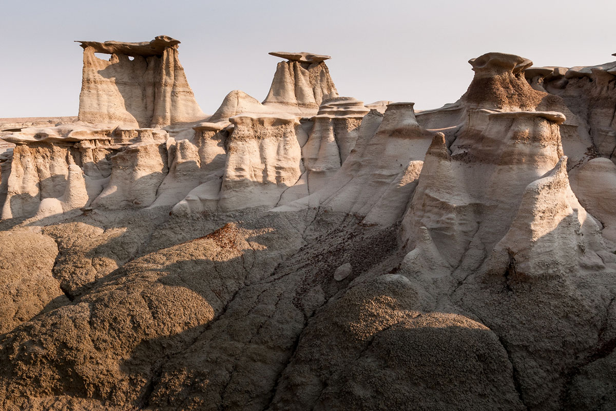
New Mexico is home to some pretty out-of-this-world formations, including the Lybrook and Angels Peak Badlands. However, one of the coolest places to see badlands in New Mexico––and, arguably, one of the coolest in the entire four-corners region––is the Bisti/De-Na-Zin Wilderness. Sitting about 36 miles south of Farmington in the northwest corner of the state, this wilderness area is managed by the Bureau of Land Management (BLM), which means that it is free to enter and allows dispersed camping. Watching the stars come out over the strange hoodoos, cap rocks, and spires is a rewarding experience and highly recommended, so as long as you are properly prepared. There is no water and no marked trails here. The BLM recommends bringing maps and being hyper-aware of your surroundings so that you can navigate properly, as it can become disorienting.
AllTrails has maps for five different hikes within the wilderness area. While this 4.7-mile loop is more popular, you’ll want to see the famous Basti Wing formations along this 2.8-mile trail. These formations look like a whisp of wind cemented itself onto the badland’s stone pillars, making this alien space look even more otherworldly. These are especially cool formations to see at night, as its remote location makes for a stunning display of stars. For a more detailed map of the formations, visit here.
Though this area is open year-round, it should be avoided when rain or snow is present, as the unpaved roads leading to trailheads can flood, turn to mud, or become impassable. The best time to visit is late spring and fall, because it can be very hot during the summer and snowy during the winter.
Oregon
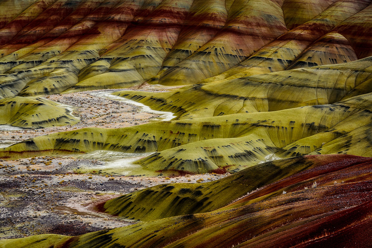
When Oregon comes to mind, it is usually accompanied by images of towering evergreens, rocky coastlines, and abundant rain. However, this state is home to beautiful, Dr. Seuss-like badlands within the John Day Fossil Beds National Monument. This stunning area is in central Oregon, near the town of Michell and about a four-hour drive southeast of Portland.
The national monument is broken up into three units: Sheep Rock, Clarno, and Painted Hills. The three units are about one to two-hour drive from each other, and all are certainly worthy of a visit. The Sheep Rock unit features the Thomas Condon Paleontology Center, where you can learn more about or see the fossils from the area. The Clarno unit features the impressive Palisades, or volcanic lahars. The Painted Hills unit, however, is the place to visit if you’d like to explore a colorful, Martian landscape.
There are five hikes within the Painted Hills unit that are all under 2 miles. You could fit in many (or all) and make the most of your day in the Painted Hills. If you only have an hour to spend here, be sure to check out the panorama views from the 1.6-mile Carroll Rim Trail, then stop by the 0.25-mile Painted Cove Trail for a boardwalk path that gets you up close.
The national monument is free and open to the public year-round. Camping is not allowed but can be found on BLM land just north outside of the Painted Hills unit on Burnt Ranch Road––at Burnt Ranch and Lower Burnt Ranch Campgrounds. There are also camping options along the HWY 207 at the John Day River. More details on campgrounds can be found here.
This Painted Hills unit can get busy on weekends, especially towards the evening, and it is recommended to visit in fall or spring for the best weather. Also, it is important to note that the road leading into the unit is unpaved and the National Park Service (NPS) recommends that RVs or other large vehicles should not drive past the Painted Hills Overlook.
California
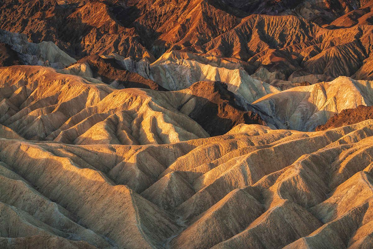
Of all the incredible sights and experiences to have within Death Valley National Park, visiting the colorful clay and mudstone badlands at Furnace Creek is one of the coolest. The badlands are located on the eastern side of the park, right off HWY 190, and is about a two-hour drive from Las Vegas, Nevada.
Many may be tempted to take the quarter-mile walk to Zabriskie Point to see the badlands, but don’t cheat yourself. There are wonderful trails to explore the formations up close and personal. The NPS recommends a number of moderate hikes to see the badlands, ranging from 2.7 to 4.3 miles, but the best way to experience the park’s badlands is by hiking the 7.8 complete circuit that makes a loop from Zabriskie Point at HWY 190 to Golden Canyon parking lots. Do not depend on marked routes here; be sure to download the GPS map from NPS or AllTrails before heading out.
Before you plan a trip, check the NPS website for updates. Right now, there are road closures in parts of the park that were flooded. Typically, the best times to visit are November through March, as Death Valley can get well over 110 degrees Fahrenheit in the summer. As there is no shade here, even spring and fall temperatures can be uncomfortable or dangerous for hikers.
There is a $30 fee per vehicle to enter the park. Those with an Annual Park Pass enter for free, however. Camping is available nearby in the Furnace Creek Campground. Reservations are highly recommended through Reservation.gov, since first come, first serve sites fill up quickly, especially on weekends and around holidays. This campground has full hookups for RVs as well as tent sites.
Overlooked Badlands Honorable Mentions
Arizona
The Petrified Forest National Park is not just a calcified forest; it is a badland as well. This park is intersected by HWY 40 and is easy to explore via car.
Wyoming
Hell’s Half-Acre (which is actually more like 960 acres) is near Casper. Its deep ravines, caves, and formations were featured in Starship Troopers.
Nebraska
Toadstool Geologic Park sits along the northern border of the state and features doughy formations that resemble––you guessed it––toadstools.
Montana
Makoshika State Park is Montana’s largest state park and an awesome place along the eastern border to see badlands, camp, and learn about dinosaurs.